Planning Board: Land Use Plan ready by Jan. ’14

Luis García-Pelatti
Puerto Rico Planning Board President-designate Luis García-Pelatti has made it his mission to spend the next year polishing and updating the Land Use Plan, first proposed nearly a decade ago.
“Our goal is to have it ready by January 2014, with the idea of establishing a broader participatory process in which citizens will have enough time, 90 days, to look the document over, submit comments and voice their concerns at the hearings,” said García-Pelatti, a professional planner and economist.
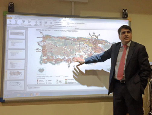
The Land Use plan has been written and re-written a number of times since it was first presented in 2004. The document seeks to finally define which land can and cannot be used for development, to somehow address the seemingly unstoppable wave of urban sprawl and protect the island’s natural resources. The land use plan is expected to identify flood-prone areas, farmlands and cultural sites.
“Our job is to guide development and we do that through planning processes that require drafting plans. This is often done in coordination with other agencies,” he said.
The Land Use Plan is one example, as is protecting the island’s karst region, a court-mandated plan the Planning Board is developing with the Department of Natural and Environmental Resources.
Protecting the resource that predominantly exists along Puerto Rico’s northern region and acts as a sponge to collect water is another priority for the Planning Board chief. Ultimately, a protected karst region would benefit residents in towns including Arecibo, Barceloneta, Camuy, Ciales, Florida, Hatillo, Jayuya, Lares, Manatí, Moca, San Sebastián,Utuado and Vega Baja.
“We’re going to hold public hearings in June, to have the plan approved by no later than November 13,” he said.
Also on the to-do list is working on a development plan for the areas along the Urban Train’s path.
“We’re drafting an inter-agency plan to identify the potential activity around the train. Right now, there are more than 600,000 square meters of vacant land, not buildings, along the route that crosses three towns,” he said. “The majority of them are government-owned and are completely underutilized.”
In his first meeting with business reporters, García-Pelatti said it will be up to the Government Development Bank, the Highway Authority, the Housing Department, the Retirement System, Lands Administration and the towns to come up with a plan to spur the construction of affordable housing and commercial activity.
For the seasoned planner, overseeing this task should be a piece of cake given that throughout his professional career he has headed multiple large-scale development plans, including the “Transit-Oriented Development Plan,” which has been largely sitting idle at the Planning Board.
“The idea behind that is to turn everything surrounding the stations into urban centers hosting all type of activity — housing, commercial and recreational — and certain light industries that can generate diverse activity for the train,” he said.
“We have to update regulations and see how we can put together packages we can offer developers. We have to sit down with the town leaders to explain and discuss the plan,” García-Pelatti said. “There are incentive plans already available through the Housing Department and others through the Lands Administration to seek making long-term leasing and deferred payments possible.”