
Interactive maps promote planning for Puerto Rico’s vulnerable communities
April 23, 2021
The Foundation for Puerto Rico and the Puerto Rico Housing Department unveiled the Interactive Vulnerability and Risk Maps, a digital tool that was developed as part of the nonprofit’s Whole Community Resilience Planning (WCRP) Program. ...
chat_bubble0 Comment
visibility1269 Views
Digital tool launched to keep track of Puerto Rico’s farming cycles
March 31, 2020
The USDA Caribbean Climate Hub at the International Institute of Tropical Forestry, in collaboration with the Puerto Rico Department of Agriculture, developed an online tool to visualize annual agricultural production data across Puerto Rico. Climate ...
chat_bubble1 Comment
visibility1183 Views
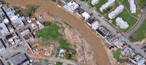
PR Planning Board opens FEMA’s flood maps to public comment
May 3, 2018
The Puerto Rico Planning Board is requesting public comment on FEMA’s updated flood maps, which reflect new information and lessons learned from the widespread damage caused by Hurricane María.
chat_bubble1 Comment
visibility1325 Views
A Dow Jones/Factiva content provider since 2014
